 Rating: 4 - 1562 Reviews


Southern & East Africa Road Atlas - The self-drive traveller's friend
The Southern & East Africa road atlas is a self-drive traveler’s dream. Being an atlas, the guide is made up of a variety of different types of maps. These maps include tourist area maps, large street maps, detailed road maps and an added bonus of topographical information and continuous mapping.
Tourist area maps in the Southern & East Africa road atlas
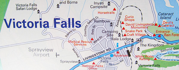
Snippet of the Victoria Falls tourist map
The tourist area maps in the Southern & East Africa road atlas are brilliant. They offer you all the details you need to know as a traveller. The area maps plot all the main roads running through a tourist area so that you can get to the attractions and activities you’re hoping to experience. The map of Victoria Falls, for example, shows you everything from where to find various curio shops and campsites to where monuments and museums can be found. Handy!
Road maps and large street maps
Detailed street map of Harare, Zimbabwe
The Southern & East Africa road atlas brings you continuous mapping on the locations it covers. Be sure to familiarise yourself with the legends on pages 4 and 5 – they prove extremely helpful when planning your route. As the second edition of the atlas, all the road and street names are up to date and accurate. I thought I’d mention that in case you were hoping to get that little bit of extra confidence in the maps.
Distance chart
Road atlas distance chart of Southern & East Africa
At the front of the atlas, you’ll find a really nifty distance chart offering you the distance in kilometres between forty-six of Southern and East Africa’s main cities. Just remember, when in Africa, distance doesn’t necessarily directly reflect the amount of time it will take to tackle a certain road. Rainy weather can mean certain roads may take you twice as long to drive. Thanks to the trusty legend, you’re able to see exactly which roads you’ll need a 4×4 to cross, as well as which roads are tarred, untarred and under construction.
Extra information
Country information in the Southern & East Africa road atlas
The Southern & East Africa road atlas covers six tourist areas, twenty street maps, 107 pages of maps of Southern and East Africa, eleven pages covering six major tourist areas, eighteen pages covering the main cities and towns, and a neat index to place names that make finding locations easy as pie.
A few other cool features you’ll find in the road atlas of Southern and East Africa include both physical and political maps, climate and vegetation information, plus information about each country listed with statistics, flags and interesting facts.
Mapped locations in the Southern & East Africa road atlas
This road atlas of Southern & East Africa offers maps of the following countries:
- South Africa
- Namibia
- Botswana
- Zimbabwe
- Tanzania
- Zambia
- Kenya
- Malawi
- Uganda
- Mozambique
- Angola
- The Democratic Republic of the Congo
- Lesotho
- Swaziland
- Burundi
- Rwanda
If you’re planning to hire a 4×4 and travel through Africa on a self-drive adventure, then the Southern & East Africa road atlas is just the thing you’re going to need while planning and driving.
Related Posts
Child Visa App updated with latest Home Affairs regulations
The new regulations are better, but still potentially confusing and misleading The Child Visa app has been updated with the latest regulations The updated app eliminates confusion and simplifies travel The South African government updated the requirements for children travelling to or from South Africa on 11 November 2019. The changes have been […]
Read MoreExploring the Cederberg: A hiker’s guide
The Cederberg area of the Western Cape is a visual treat for anyone looking to get away and forget about the woes of city life for a while. The isolation of the area makes it a great place to lose oneself and become immersed in nature. The Cederberg area is a mecca for hiking and […]
Read MoreSix Places You Have to Visit Along the Sunshine Coast
This area of South Africa is known for receiving the most sunshine and its abundance of natural beauty and beaches make it one of the most visited regions of the country. From beautiful coastal towns to nature reserves and wildlife, the ‘sunshine coast’ is the ideal location to create your holiday memories. If you would […]
Read More